Cliffs of Moher

FabienneD
User
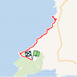

Length
12.4 km

Max alt
171 m

Uphill gradient
738 m
Km-Effort
22 km

Min alt
10 m

Downhill gradient
740 m
Boucle
Yes
Creation date :
2015-06-05 00:00:00.0
Updated on :
2015-06-05 00:00:00.0
3h43
Difficulty : Medium

FREE GPS app for hiking
 SityTrail
IGN / Geographical institutes
SityTrail Plus
The world is yours!
About
Trail Walking of 12.4 km to be discovered at Unknown, County Clare, West Clare Municipal District. This trail is proposed by FabienneD.
Description
Moher walk
Positioning
Country:
Ireland
Region :
Unknown
Department/Province :
County Clare
Municipality :
West Clare Municipal District
Location:
Ballysteen
Start:(Dec)
Start:(UTM)
469470 ; 5866082 (29U) N.
Comments